Council’s General Plan Committee 1:30pm Thursday, March 1 and 15
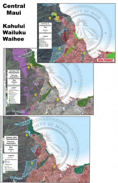
Comparison of three proposed maps:
1. 2009 GPAC
2. 2010 Planning Director
3. 2012 Planning Director
C – 2 CENTRAL MAUI MAP
B Waihee village — GPAC and 2010 Director recommended “Country Town”. 2012 Director recommends a RGB. GPAC recommended an increase in the ‘country town’ area.
C Wailuku Country Estates — 2012 Director recommends Rural Growth Boundary. Is Rural Growth Boundary appropriate for an agricultural sub-division?
D Greenbelt clearly defining Wailuku + Kahului — giving each town its own identity.
(click to enlarge)
———————————————-
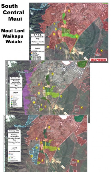
South Central Maui Comparison of three proposed maps:
1. 2009 GPAC
2. 2010 Planning Director
3. 2012 Planning Director
C – 3 SOUTH CENTRAL MAUI MAP
D Greenbelt clearly defining Wailuku + Kahului — giving each town its own identity.
E Greenbelt between Maui Lani and proposed Waiale, with no UGB around the entire Central Maui urbanized area.
F GPAC intended that there be a significant greenbelt between Wailuku and Waikapu. 2010 and 2012 Director placed 200 units in that area, reducing the separation.
G Waikapu — GPAC and 2010 Director indicated a UGB. 2012 Director recommends a RGB.
H Waikapu Mauka – 2010 and 2012 Directors added these rural area to the GPAC’s Waikapu Urban Growth Boundary.
I Waikapu Makai – GPAC limited size of UGB. 2010 and 2012 Directors recommended a larger UGB.
J Waikapu Makai East — 2012 Director added even more to UGB.
K Puunene Baseyard – 2010 and 2012 Directors recommend a larger UGB than the GPAC.

